Cycling |
Services |
Landmarks |
Comments |
0 km |
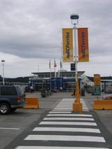
Food | Tsawwassen Ferry Terminal. |
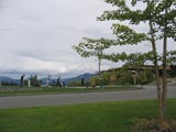
Located approximately 40 km south of Vancouver and approximately 20 km from the Canada US border. Ferries depart from Tsawwassen for both Swartz Bay (serving Victoria ) and Duke Point (serving Nanaimo ) at regular intervals.Check www.bcferries.com for info. Long term parking is available at Tsawwassen. However you may have to cycle from the parking area along the causeway to the ferry terminal. For those unfamiliar with the BC Ferry system, it is one of the largest and most efficient in the world and the vessels that depart from Tsawwassen can carry up to 450 vehicles each. |
0 km |
Food |
Ferry from Tsawwassen to Swartz Bay |
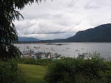
The trip from Tsawwassen to Swartz Bay is approximately 1 hour and 35 minutes. It passes through the southern Gulf Islands of British Columbia . This is one of the most beautiful areas in Canada . It enjoys a Mediterranean climate. Much of the area is devoted to provincial or national parks. There is an extensive network of smaller ferries providing access to the Gulf Islands from Swartz Bay near Victoria . Although the Islands appear idyllic they are hilly and can be quite challenging for cycle touring |
| 0 km | Food |
Swartz Bay Ferry Terminal |
Intersection Pat Bay Highway/ Lands End Road Wait for the
|
| 1.3 km | Intersection Lochside Trail and McDonald Park Road |
For the first section of the Route, you must follow the signs that read "Lochside Trail". If you were to follow these signs they would take you all the way into Victoria . At the end of the 1.3 km intersection Lochside Trail/McDonald Park Road , the cycling trail ends and you are immediately on McDonald Park Road . Follow McDonald Park Road for approximately 1.5 km. McDonald Park Road bears to the right. |
|
| 2.8 km | McDonald Park Road |
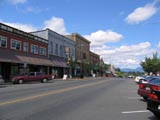
This is the beginning of the delightful small town of Sidney by the Sea - www.sidneybc.com However, for the cycling route, follow the signs at the end of McDonald Park Road . You will be on a cycling trail that parallels the Pat Bay Highway on the western outskirts of the Town of Sidney . You will go through the intersection of the trail and Beacon Avenue . Beacon Avenue is the main street for Sidney . If you were to turn left and go down Beacon Avenue , you would eventually come to the ocean | |
| 3.0 km |
Lochside Trail and Ocean Avenue |
Follow the trail signs and turn to the left down Ocean Avenue . You will proceed approximately 3 blocks until you hit Lochside Drive . | |
| 3.2 km |
Full Services Food Lodging |
Intersection Lochside Drive and Ocean Avenue |
Turn right on Lochside Drive and keep following the 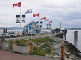 Lochside Trail signs. If you were to turn left, you would be on Fifth Street in Sidney . The intersection of Ocean Avenue and Fifth Street is only 4 blocks from Beacon Avenue and close to many amenities including accommodation and restaurants and the shops of Sidney . For the Rotary Route , turn right and follow Lochside Drive . You will Lochside Trail signs. If you were to turn left, you would be on Fifth Street in Sidney . The intersection of Ocean Avenue and Fifth Street is only 4 blocks from Beacon Avenue and close to many amenities including accommodation and restaurants and the shops of Sidney . For the Rotary Route , turn right and follow Lochside Drive . You will 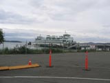 soon see the ocean which will be on your left. You will also be very close to the Ferry Terminal for the Washington State ferry system that provides connections to Anacortes , Washington – www.wsdot.wa.gov/ferries/ . If you were to make a tour of the American San Juan Islands, this would be your jumping off soon see the ocean which will be on your left. You will also be very close to the Ferry Terminal for the Washington State ferry system that provides connections to Anacortes , Washington – www.wsdot.wa.gov/ferries/ . If you were to make a tour of the American San Juan Islands, this would be your jumping off  point. Follow Lochside Drive, the ocean will be on your left and you will have great views to the south of some of the Canadian Gulf Islands and the American San Juan Islands. point. Follow Lochside Drive, the ocean will be on your left and you will have great views to the south of some of the Canadian Gulf Islands and the American San Juan Islands. |
| 9.2 km |
Airport | Intersection of McTavish and Lochside |
This is a main intersection. If you were to turn right on McTavish, you would quickly cross the Pat Bay Highway . At this point, you are very close to the Victoria International Airport . Continue straight through on Lochside Drive . After McTavish, Lochside is a residential area. This part of Lochside Drive is part of the Lochside Trail system. |
| 12 km | Intersection Amity Drive and Lochside Drive . | Keep a close lookout for Amity. It is a very short street. Turn right on Amity and you will come to a pedestrian overpass. Look for the small yellow cycling signs directing you from the ‘Lochside Trail' to your right over Amity to the ‘Interurban Trai. Up to this point, the signage has been for the “Lochside Trail”. Dismount and push your bike across the overpass over the Highway. Go up the hill approximately 3 blocks until you reach Aldous. |
|
| 12.2 km | Intersection Amity Drive and Aldous Road |
Turn left on Aldous. You are going to follow Aldous which  quickly becomes Wallace Drive . This route is marked with yellow signs denoting the “Interurban Trail”. You are now in the District of Central Saanich. Unfortunately, Central Saanich is the only municipal jurisdiction along the entire Rotary Route that did not allow Rotary to place its distinctive signage. However, the route through Central Saanich is well marked as the “Interurban Trail”. These signs are small yellow signs. Simply follow the Interurban Trail all the way to the Mill Bay Ferry. The route is relatively well marked. quickly becomes Wallace Drive . This route is marked with yellow signs denoting the “Interurban Trail”. You are now in the District of Central Saanich. Unfortunately, Central Saanich is the only municipal jurisdiction along the entire Rotary Route that did not allow Rotary to place its distinctive signage. However, the route through Central Saanich is well marked as the “Interurban Trail”. These signs are small yellow signs. Simply follow the Interurban Trail all the way to the Mill Bay Ferry. The route is relatively well marked. |
|
| 12.8 km | After approximately 3 blocks, Aldous becomes Wallace. Just keep following Wallace in a generally southbound direction through Central Saanich . The first stage of Wallace is over beautiful rural land with commanding vistas over the American San Juan Islands. | ||
| 15.0 km |
Pub Restaurant Shops |
Intersection Wallace Road and East Saanich Road |
As you go through the municipality of Central Saanich , the route becomes quite confusing. You make a quick left on East Saanich, go for about 1 block and then make a right on the continuation of Wallace. Keep a close eye out for the yellow Interurban Trail signs and simply follow these signs. |
| 15.1 km | East Saanich Road and Wallace. |
Continue going south on Wallace after going through the center of Central Saanich . There are good shoulders along Wallace at this point. | |
| 16.2 km | Intersection Wallace Road and Stelly's Cross Road |
 Stay on Wallace Road through this intersection proceeding south. Shortly after going through this intersection, you will notice a school on your right which is Stelly's School. Shortly after Stelly's School on your left are the fields belonging to the Victoria Polo Club. Stay on Wallace Road through this intersection proceeding south. Shortly after going through this intersection, you will notice a school on your right which is Stelly's School. Shortly after Stelly's School on your left are the fields belonging to the Victoria Polo Club. |
|
| 18.8 km | Intersection of Wallace Road and West Saanich Road |
You are in the heart of the community of Brentwood Bay . There are full services here including stores, restaurants and lodging. If you want to take a side trip to Vancouver Island 's most popular tourist attraction, the Butchart Gardens , www.butchartgardens.com turn left on Wallace and proceed on West Saanich Road approximately 2 km where you will see large signs directing you to the Butchart Gardens . To stay on the Rotary Route , turn right on Wallace through the Village of Brentwood Bay. | |
| 19.5 km | Intersection West Saanich Road and Verdier Avenue |
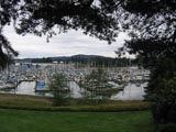
Turn left on Verdier and proceed down the hill towards the Brentwood Bay Ferry Terminal. At the bottom of the hill you cannot miss the Terminal. There are some delightful little restaurants and shops in this area. Adjacent to the Brentwood Bay Ferry Terminal is the Brentwood Bay Inn and Spa. This is a brand new first class facility that is well worth a visit. | |
| 20 km | Food |
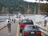
Brentwood Bay Start of Brentwood-Mill Bay ferry trip |
|
| 20 km |
Campground | Mill Bay Ferry Terminal Bamberton Provincial Park |
If you are camping, you may wish to stay at Bamberton Provincial Park which is an excellent campground with full facilities and beach front. However, to get to the park you have a very steep climb of about 1 km from the Mill Bay Ferry Terminal. To get to the park, turn left after exiting the short road from the ferry terminal and proceed up the hill on Mill Bay Road . At the top of the hill you will see the signs marking the park. Turn left off Mill Bay Road into Bamberton Provincial Park . If you cross under the Trans Canada Highway you have gone too far. From the entrance to Bamberton Park , you will go steeply downhill to the campground. |
| 25 km | Full services |
Intersection of Mill Bay Road and Deloume Road |
There is a large shopping centre on your left ( The Mill Bay Shopping Centre ) where you can stock upon anything that you will need. On your right at the intersection of Deloume and Mill Bay Road is Brentwood College , www.brentwood.bc.ca a world renowned private boarding school. Turn left and go up the hill a short distance to the intersection of Deloume and the Trans Canada Highway . |
25.2 km |
Intersection of Deloume Road and Trans Canada Highway | Turn right. This is one of only 3 stretches of highway riding you will experience on the “ Rotary Route ”. There is a very broad shoulder on your right. Proceed north on the Trans Canada Highway through the light at Shawnigan Lake Rd/TCH intersection to Kilmalu Rd. | |
| 27 km |
Intersection of Trans Canada Highway and Kilmalu Road |  Turn right. Follow Kilmalu Road east a short distance to Telegraph Road . Turn right. Follow Kilmalu Road east a short distance to Telegraph Road . |
|
| 27.6 km |
Intersection of Kilmalu Road and Telegraph Road | Turn left at this intersection. You will be faced with one of the most challenging hills on the entire “ Rotary Route ”. It lasts about a kilometre and is essentially a 3 stage hill. You are now proceeding north and you will stay northbound for the rest of the trip. | |
| 30 km |
Pub | Arbutus Ridge Golf and Country Club (Intersection of Telegraph Road and Hutchinson Road in Cobble Hill. Intersection Telegraph Road and Aros Road |
On your right is the Arbutus Ridge Golf and Country Club www.golfbc.com/courses/arbutusridge/ There is a good restaurant and pub here. You are now in the rural area known as Cobble Hill. Arbutus Ridge was one of the first planned retirement communities in Canada . There are now approximately 600 homes located in this
development Proceed straight north through this “T” intersection. The Satellite Park subdivision and access to Cherry Point Beach is at the end of Aros Road . |
| 33.5 km |
Intersection Telegraph Road and Cherry Point Road | Turn right off Telegraph onto Cherry Point Road . You have a brief jog to the east and you are heading towards the water at Cherry Point Beach . | |
| * SEE ALTERNATE ROUTE DESCRIPTION |
Intersection Telegraph Road and Cherry Point Road | Telegraph Road/ Koksilah Road / Duncan / Trunk Road/Lakes Road/ Herd Road / Richards Trail . This is the start of the “ Alternate Route ” through the Cowichan Valley . |
|
| 34.5 km |
Vineyard | Cherry Point Vineyards | Make a point of stopping here. There are over 30 acres of vineyards on your left. This is one of the first vineyards on Vancouver Island . There is a beautiful picnic area, wine store and gift shop. |
| 34.5 km |
Intersection Cherry Point Road/Garnett Road | To follow the Rotary Route, you bear left at this intersection following Cherry Point Road after visiting Cherry Point Vineyards www.cherrypointvineyards.com However, if you have some extra time proceed directly east from Cherry Point Vineyards down Garnett Road. After approximately ½ km. you will arrive at Cherry Point Beach www.cvrd.bc.ca/parks/html/featureparks/cherry_point.html The beach is approximately 1 km. long. This is a small nature park with picnic tables and benches. The beach abuts a large tidal flat known as Boatswain Bank. From this beach you have a beautiful view of Saanich Inlet, Satellite Channel, the Saanich Peninsula with Mt. Baker in the distant background. Immediately opposite Cherry Point Beach , across Satellite Channel, is the southern end of Salt Spring Island . The mountain you are looking at is called Mt. Tuam and the southern point is Cape Kepple . From this vista you are able to see the unique effect of the Mediterranean climate of the Gulf Islands . The area around Cherry Point is a “micro-climate” which has the highest year round temperatures in Canada . It receives significantly less rain than areas 10 km. to the north or west. This is one of the reasons why the wine industry was established in the South Cowichan area. | |
| 35 km |
Cherry Point Road northbound | As you leave Cherry Point Vineyards you will encounter another one of the significant hills on the Rotary Route . Fortunately you will be over it in about 10 minutes. Keep following Cherry Point Road generally northbound. There is a significant jog in the road as it approaches Cowichan Bay . You turn right and then left again but you remain on Cherry Point Road . On this “jog” you will pass Cheese Pointe Farm . Stop and buy some locally produced cheese for a meal or picnic. | |
| 39.9 km |
Food | Intersection Cherry Point Road and Cowichan Bay Road | This intersection is known locally as “4 Ways” for obvious reasons. Turn right at this intersection. Immediately on your left will be a convenience store known as “The 4 Ways Store”. You will now be heading downhill (there is a steep decline as you approach Cowichan Bay ). |
| 40.9 km |
Full Services |
Cowichan Bay Village |
|
| 42.5 km |
B & B | Old Farm Bed and Breakfast – Cowichan Bay Road | If you want to stay at a first class bed and breakfast within a short cycling or walking distance of Cowichan Bay , this is your place. The Old Farm www.oldfarminncowichan.com is a magnificently restored Victorian home. This is upscale but is well worth the visit. This highly regarded bed and breakfast is very popular and if you want to stay here make sure you book ahead. |
| 44 km |
Koksilah River | As you proceed northbound along the Cowichan Bay Road you cross the Koksilah River . There is a large farm on your left and right. Just prior to the Koksilah River there is a cairn marking the arrival of some of the first settlers to coastal British Columbia . | |
| 44.6 km |
South Cowichan Lawn Tennis Club ( Intersection Cowichan Bay Road/Tzouhalem Road ) | This is a “T” intersection. On your left is the South Cowichan Lawn Tennis Club www.scltc.bc.ca This is the second oldest lawn tennis club in the world ( Wimbledon is the oldest). It was also the home of the famed author Robert Service when he worked for the Bank of Montreal in Duncan before heading to the Yukon and achieving fame as the ‘Bard of the Klondike'. Proceed straight through this intersection onto Tzouhalem Road . If you were to turn left and follow Cowichan Bay Road , you will end up at the Trans Canada Highway within approximately 1 ½ km. | |
| 45 km |
 You are now proceeding through the Cowichan Indian Reserve, one of the largest Indian reserves in British Columbia . You are now on Tzouhalem Road proceeding north. You will pass over a number of bridges which cross various arms of the Cowichan River . The Cowichan River was at one time one of the most prolificsalmon producing rivers in North America . Unfortunately, development has had a You are now proceeding through the Cowichan Indian Reserve, one of the largest Indian reserves in British Columbia . You are now on Tzouhalem Road proceeding north. You will pass over a number of bridges which cross various arms of the Cowichan River . The Cowichan River was at one time one of the most prolificsalmon producing rivers in North America . Unfortunately, development has had a  significant detrimental impact on the fish. As you go through this area you will pass by a large sawmill on your right. Shortly after the Mill, if you look upwards to your left, you will see a stone church on a hill. This was one of the first churches built in British Columbia . It is now essentially abandoned. It is known as “The Butter Church”. It was built by Catholic missionaries in the late 19 th century with the proceeds from the sale of butter. significant detrimental impact on the fish. As you go through this area you will pass by a large sawmill on your right. Shortly after the Mill, if you look upwards to your left, you will see a stone church on a hill. This was one of the first churches built in British Columbia . It is now essentially abandoned. It is known as “The Butter Church”. It was built by Catholic missionaries in the late 19 th century with the proceeds from the sale of butter. |
||
| 46.6 km |
Cowichan Bay Road – Providence Farm | You are still on Tzouhalem Road . You are now travelling west toward Duncan . Providence Farm is to your right. This was the location of a large high school run by the Catholic Church primarily for the natives in the area. It is still owned by the Church but is used for a variety of public purposes including a large Folk Festival held in July. | |
| 49.7 km |
Intersection Tzouhalem Road and Maple Bay Road | This is another “T” intersection. You will be turning right off Tzouhalem onto Maple Bay Road to follow the “ Rotary Route ”. However, if you want to go into downtown Duncan , keep going straight on Tzouhalem Road which then becomes Trunk Road. Downtown Duncan is approximately 1.5 km from this point.On your right at this intersection is Cowichan Lodge, a seniors' facility with a large private park adjacent to it. Turn right here. |
|
| 50 km |
Intersection Maple Bay Road and Church Road | For an interesting historical side trip, turn right down Church Road to St. Peter's/Quamichan Anglican Church. This is one of the oldest places of worship in continuous use in British Columbia . Visit the church yard. It is one of the few in British Columbia that is reminiscent of an English country church yard. Many of the Cowichan Valley pioneers are buried here. One of the recent occupants is David Ricardo Williams, a prominent local lawyer and author. The first of his many books was a history of St. Peter's/ Quamichan. | |
| 50 – 55 km |
|
||
| 55.8 km |
Park | Intersection Maple Bay Road and Herd Road |  As you approach this intersection you will be going downhill on a relatively steep grade towards the Village of Maple Bay. Herd Road is approximately half way down the hill. Keep a careful lookout for this intersection or you will miss it. Turn left off Maple Bay Road onto Herd Road . If you have an opportunity proceed to the bottom of the hill and visit the Village of Maple Bay. There are some beautiful waterfront homes in this area. The Brig Pub provides yet another opportunity for food and refreshment. If you explore around Maple Bay , visit the marinas and the yacht club on the south end of the bay. This is a very popular destination for visiting boaters and it hums in the summer. Remember that on Vancouver Island there is usually a relatively steep climb from a shoreline back to the cycling route. As you approach this intersection you will be going downhill on a relatively steep grade towards the Village of Maple Bay. Herd Road is approximately half way down the hill. Keep a careful lookout for this intersection or you will miss it. Turn left off Maple Bay Road onto Herd Road . If you have an opportunity proceed to the bottom of the hill and visit the Village of Maple Bay. There are some beautiful waterfront homes in this area. The Brig Pub provides yet another opportunity for food and refreshment. If you explore around Maple Bay , visit the marinas and the yacht club on the south end of the bay. This is a very popular destination for visiting boaters and it hums in the summer. Remember that on Vancouver Island there is usually a relatively steep climb from a shoreline back to the cycling route. |
| 58.5 km |
Intersection Herd Road and Osborne Bay Road |  Once again you are travelling through rural countryside. Turn right at this intersection to head north. As you travel along Osborne Bay Road you will be confronted with one of the longest hills on the Rotary Route . There is a gradual uphill grade for approximately 3 km after the intersection of Herd Road and Osborne Bay Road .
Osborne Bay Road can be busier than the other rural roads of the Rotary Route . If you want to avoid the heavier traffic on this stretch, keep going west on Herd Road for approximately 3 km until you get to Richards Trail . Turn right on Richards Trail . See the “ Alternate Route ” description for this section of the ride. Once again you are travelling through rural countryside. Turn right at this intersection to head north. As you travel along Osborne Bay Road you will be confronted with one of the longest hills on the Rotary Route . There is a gradual uphill grade for approximately 3 km after the intersection of Herd Road and Osborne Bay Road .
Osborne Bay Road can be busier than the other rural roads of the Rotary Route . If you want to avoid the heavier traffic on this stretch, keep going west on Herd Road for approximately 3 km until you get to Richards Trail . Turn right on Richards Trail . See the “ Alternate Route ” description for this section of the ride. |
|
| 62 km |
Crofton , BC | When you reach the top of the hill you will be in the community of Crofton. Go downhill through Crofton. | |
| 63.7 km |
Food | Intersection Osborne Bay Road and Chaplin Street | Turn left. You are in the community of Crofton. Crofton is an industrial town with a long history. It was originally the site of a copper smelter for ore that was mined at Mt. Sicker just to the west of the town. It is now the site of the Norske Skog Pulp and Paper Mill, one of the largest such mills in British Columbia and one of the economic mainstays of the Cowichan Valley . If you want to make a side trip to Salt Spring Island you would turn right at the intersection of Osborne Bay Road and Chaplin Street and go down the hill approximately ½ km to the ferry terminal. Salt Spring Island is not part of the “ Rotary Route ” but provides wonderful opportunities for cycle tourism. However, bear in mind that Salt Spring is a typical Gulf Island . Its roads are very narrow with many hills and no shoulders. |
| 64 km |
Intersection Chaplin Street and Crofton Road |  At the top of Chaplin Street turn right and proceed north. You are now on Crofton Road . Shortly after turning right it will be obvious that you are in an industrial area. The large pulp and paper mill dominates the landscape for about a kilometre. After passing the mill proceeding north you are still on Crofton Road . This road is sometimes referred to as the “ Old Island Highway ” or the “ Old At the top of Chaplin Street turn right and proceed north. You are now on Crofton Road . Shortly after turning right it will be obvious that you are in an industrial area. The large pulp and paper mill dominates the landscape for about a kilometre. After passing the mill proceeding north you are still on Crofton Road . This road is sometimes referred to as the “ Old Island Highway ” or the “ Old 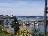 Victoria Road ”. Victoria Road ”. |
|
| 67 km |
Intersection Crofton Road and Chemainus Road | 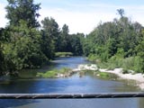 This is another “T” intersection. If you were to turn left you would eventually hit the Island Highway . However,
you want to bear right. Now Crofton Road becomes Chemainus Road . You are still heading north. Shortly after this intersection you cross the Chemainus River . There is a delightful old wooden bridge here and on a hot day the Chemainus River is a great place for a swim. This is another “T” intersection. If you were to turn left you would eventually hit the Island Highway . However,
you want to bear right. Now Crofton Road becomes Chemainus Road . You are still heading north. Shortly after this intersection you cross the Chemainus River . There is a delightful old wooden bridge here and on a hot day the Chemainus River is a great place for a swim. |
|
| 68.7 km |
Bald Eagle Campsite | Keep heading north on the Chemainus Road . You will pass Bald Eagle Campsite which, if you are camping or have the time, provides an attractive setting on the banks of the Chemainus River . If you camp here you are only 4 km from the Town of Chemainus . | |
| 72 km |
Food | Chemainus , BC |
|
| 72 km |
Chemainus Road Northbound | After leaving the town of Chemainus , continue to head north on the “ Chemainus Road ” towards Ladysmith. Along this stretch you will hug the water most of the way. There are some great views of the upper Gulf Islands (Thetis, Kuper, Valdez and Gabriola) and Vancouver 's north shore mountains. There is a very good shoulder northbound. There is no shoulder southbound on Chemainus Road . | |
| 78 km |
Pub | Chemainus Road/Knight Road – Saltair Pu | Just off the Chemainus Road is a delightful country pub known The Saltair Pub . |
| 80 km |
Food | Saltair |  You pass through the community of Saltair. This is an unorganized community with many waterfront homes. The waters of Stuart Channel are on your right. You pass through the community of Saltair. This is an unorganized community with many waterfront homes. The waters of Stuart Channel are on your right. |
| 82.6 km |
Food | Intersection Chemainus Road and Island Highway |
The town itself was named after the site of one of the British victories during the Boer War and many of its streets are named after leading British military figures of that time. After spending some time in Ladysmith you will continue northbound on the Island Highway . The traffic will be busy here but fortunately, this highway was constructed in late 2000 and the shoulders for cycling are very wide and very safe. If you are running out of time and have to rush to meet the Duke Point Ferry simply stay on the highway for another 20 km and the tour will be over. On the south edge of the town of Ladysmith is Transfer Beach . Because Ladysmith was a coal mining centre in the early part of the 20 th century, this is the site from which the coal was “transferred” to the south. Most of the product went to heat the homes of the growing city of San Francisco . What was originally a coal transfer point is now a beautiful park with plenty of amenities. Before the 1920's coal was the main industry on Vancouver Island north of this point. The discovery of oil in California gradually led to the decline of the coal industry on Vancouver Island as oil proved to be a more efficient and readily available source of fuel. The coal industry in Ladysmith was characterized by violent strikes. The birth of the British Columbia labour movement can be traced to these conflicts in the early part of the 20 th century. |
| 83.5 km |
Trans Canada Highway and First Street | Turn right on First Street . You will cross the railroad tracks and enter an industrial area. After approximately one-half block turn left. This is the intersection of First Street and Rocky Creek Road . | |
| 84 km |
First Street and Rocky Creek Road | Turn left off First Ave onto Rocky Creek Road . You are now on a frontage road that parallels the Trans Canada Highway . The waters of Ladysmith Harbour will be on your right. The Trans Canada Highway will be on your left. Follow Rocky Creek Road until it reaches the Trans Canada Highway . | |
| 85 km |
Intersection Rocky Creek Road and Trans Canada Highway | Turn right on the Trans Canada Highway and follow the Trans Canada Highway north for approximately 2 km. There are wide shoulders on the Trans Canada at this point. | |
| 87 km |
Food |
Intersection Trans Canada Highway and Brenton-Page Road | Turn right onto Brenton Page Road if you want to continue on the “Scenic Rotary Route Tour”. Head straight through and stay on the highway if you are in a rush or have had enough of undulating country roads. If you stay on the Trans Canada Highway , you will soon pass the Nanaimo Airport on your right and will eventually get to the Duke Point Ferry turn off. After turning right from the Highway onto Brenton-Page Road you will go down a relatively steep hill. Immediately on your right will be a sawmill and the end of Ladysmith Harbour . On your left will be a Redi-Mix plant. Keep bearing right as you go around the end of Ladysmith Harbour with the water on your right. |
| 88 km |
Intersection Brenton-Page Road and Code Road | Make a sharp left turn off Brenton-Page onto Code Road . Code Road is a narrow road and there is a bit of a steep climb as you now proceed north. However, for a real treat continue on for about 2 km along Brenton-Page Road heading south. You will see the signs marking Page Point Inn. Page Point Inn is a beautiful facility with a fine restaurant and approximately 8 rooms for Bed & Breakfast services. It is located right on the water of Ladysmith Harbour with a beautiful view to the West. There is also a marina attached to this facility. It is a great place to stop for the night. If you stop at the Page Point Inn, just back track to Code Road to get onto the “ Rotary Route ”. |
|
| 89.5 km |
Intersection Code Road and Cedar Road | Turn right off Code onto Cedar. You are now on the home stretch. Cedar is a main rural road with good shoulders. You are going to stay on Cedar for most of the rest of the trip. | |
| 93.8 km |
Food | Intersection Cedar Road and Yellow Point Road | Yellow Point Road branches off Cedar Road to your right. If you want to extend your trip, simply follow Yellow Point Road for approximately 10 km. until it meets up with Cedar Road further to your north. The famous Yellow Point Lodge www.yellowpointlodge.com about half way along Yellow Point Road . Otherwise, to keep to the “ Rotary Route ”, continue straight through this intersection bearing left on Cedar Road . |
| 100 km |
Pub | Intersection Cedar Road and Yellow Point Road | This is the second intersection of Cedar Road and Yellow Point Road . Turn right onto Yellow Point Road and then immediately right again into the grounds of the Crow and Gate Pub www.shift.to/crowandgate/ The Crow and Gate is a true English style country pub. It was the first neighbourhood pub in British Columbia . It is suitably situated at kilometre 100 of the ride and less than 10 km from the Duke Point Ferry Terminal. This pub has a beautiful garden in which you can enjoy a pint before the final push to the ferry. After reasonable libations, head back out of the pub onto Yellow Point Road, turn left , then immediately right, and get onto Cedar Road going north again. You are on the final stretch. If you still have it in you there is another pub at approximately kilometre 102 called The Wheatsheaf Inn . From here it is approximately 9 km (mostly downhill) to the ferry. |
| 102.4 km |
Food | Cedar, BC | After passing The Wheatsheaf you proceed through the commercial centre of Cedar. Keep an eye out on your right for MacMillan Road . |
| 113 km |
Food | Intersection Cedar Road and MacMillan Road | Turn right off Cedar onto MacMillan and go downhill. After you pass the school on your right, keep going on MacMillan and bear left. You cross a bridge over the main highway to the Duke Point Ferry Terminal. As soon as you cross the bridge, turn right and follow the signs to the Duke Point Ferry Terminal. You go a short distance and then turn right again to recross the highway over a bridge. After crossing the highway the second time, you will now be back on the south side of the highway. Keep following the signs and immediately turn to the left onto Maughan Road . Follow Maughan Road approximately three kms towards the Duke Point Ferry Terminal. Just before Maughan Road ends make a left turn and you are into the Duke Point Ferry Terminal site. The area along Maughan Road is an industrial area consisting primarily of sawmills and is the site of the proposed natural gas co-generation Plant. Remember that the wealth from the forest industry helped pave the 110 kms of highway that you have been travelling on for the past two days. |
| 110 km |
Ferry | Duke Point Ferry Terminal | Pay your fare, relax and enjoy the 2 ½ hour trip back to Tsawwassen, your point of departure. If you parked at the end of the causeway in Tsawwasen reserve a small amount of energy to get to your car. |
*ALTERNATE ROUTE |
Ferry | Duke Point to Departure Bay Ferry Terminal |
If it is your intention to go into Nanaimo to take the ferry from Departure Bay to Horseshoe Bay , check out the detailed map provided on the Rotary Route Brochure or obtain the Davenport detailed map of the Nanaimo/Qualicum/Parksville area. |